30 May 2025
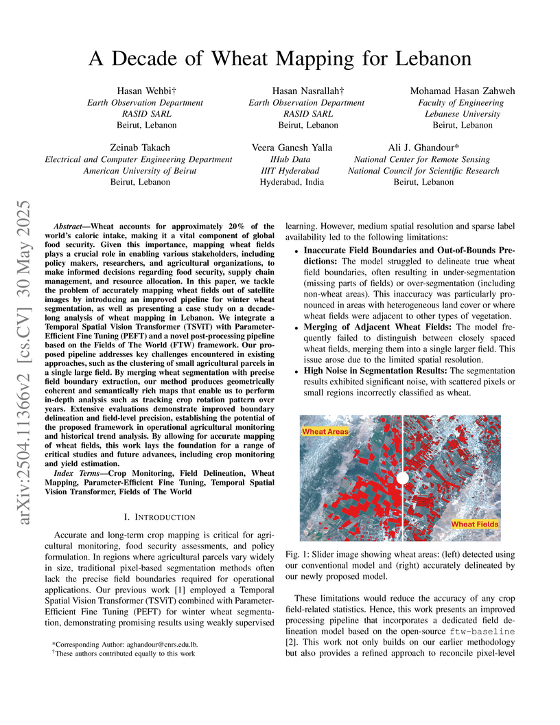
Wheat accounts for approximately 20% of the world's caloric intake, making it a vital component of global food security. Given this importance, mapping wheat fields plays a crucial role in enabling various stakeholders, including policy makers, researchers, and agricultural organizations, to make informed decisions regarding food security, supply chain management, and resource allocation. In this paper, we tackle the problem of accurately mapping wheat fields out of satellite images by introducing an improved pipeline for winter wheat segmentation, as well as presenting a case study on a decade-long analysis of wheat mapping in Lebanon. We integrate a Temporal Spatial Vision Transformer (TSViT) with Parameter-Efficient Fine Tuning (PEFT) and a novel post-processing pipeline based on the Fields of The World (FTW) framework. Our proposed pipeline addresses key challenges encountered in existing approaches, such as the clustering of small agricultural parcels in a single large field. By merging wheat segmentation with precise field boundary extraction, our method produces geometrically coherent and semantically rich maps that enable us to perform in-depth analysis such as tracking crop rotation pattern over years. Extensive evaluations demonstrate improved boundary delineation and field-level precision, establishing the potential of the proposed framework in operational agricultural monitoring and historical trend analysis. By allowing for accurate mapping of wheat fields, this work lays the foundation for a range of critical studies and future advances, including crop monitoring and yield estimation.
02 Apr 2025
Synthetic aperture radar (SAR) data processing is crucial for high-resolution
Earth observation and remote sensing applications, one of the most commonly
used algorithms for this task is the Range Doppler Algorithm (RDA). Using the
Fast Fourier Transform (FFT), the collected signal is transformed to the
frequency domain and then goes through the processing steps of this algorithm.
However, when it comes to large datasets, this process can be computationally
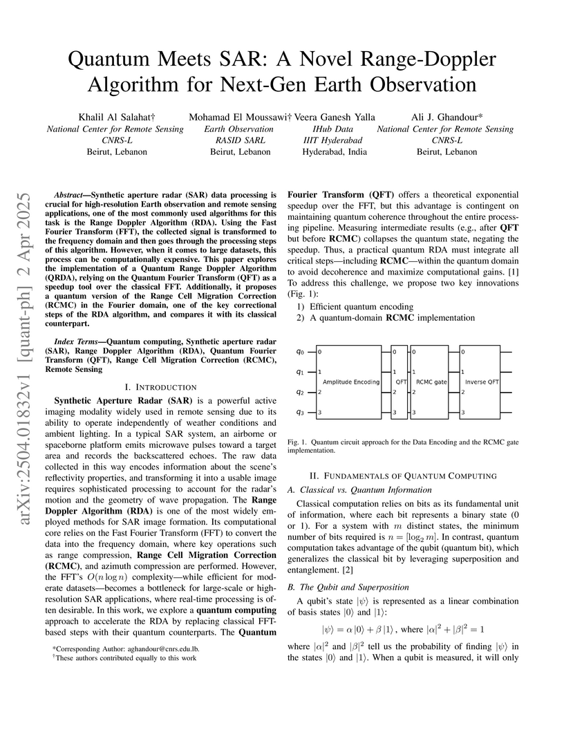
expensive. This paper explores the implementation of a Quantum Range Doppler
Algorithm (QRDA), relying on the Quantum Fourier Transform (QFT) as a speedup
tool over the classical FFT. Additionally, it proposes a quantum version of the
Range Cell Migration Correction (RCMC) in the Fourier domain, one of the key
correctional steps of the RDA algorithm, and compares it with its classical
counterpart.
30 Jul 2025
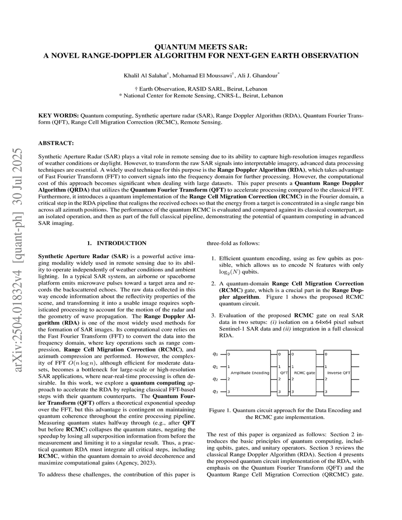
Synthetic Aperture Radar (SAR) plays a vital role in remote sensing due to its ability to capture high-resolution images regardless of weather conditions or daylight. However, to transform the raw SAR signals into interpretable imagery, advanced data processing techniques are essential. A widely used technique for this purpose is the Range Doppler Algorithm (RDA), which takes advantage of Fast Fourier Transform (FFT) to convert signals into the frequency domain for further processing. However, the computational cost of this approach becomes significant when dealing with large datasets. This paper presents a Quantum Range Doppler Algorithm (QRDA) that utilizes the Quantum Fourier Transform (QFT) to accelerate processing compared to the classical FFT. Furthermore, it introduces a quantum implementation of the Range Cell Migration Correction (RCMC) in the Fourier domain, a critical step in the RDA pipeline that realigns the received echoes so that the energy from a target is concentrated in a single range bin across all azimuth positions. The performance of the quantum RCMC is evaluated and compared against its classical counterpart, demonstrating the potential of quantum computing in advanced SAR imaging.
There are no more papers matching your filters at the moment.
