24 Sep 2025
We introduce CapStARE, a capsule-based spatio-temporal architecture for gaze estimation that integrates a ConvNeXt backbone, capsule formation with attention routing, and dual GRU decoders specialized for slow and rapid gaze dynamics. This modular design enables efficient part-whole reasoning and disentangled temporal modeling, achieving state-of-the-art performance on ETH-XGaze (3.36) and MPIIFaceGaze (2.65) while maintaining real-time inference (< 10 ms). The model also generalizes well to unconstrained conditions in Gaze360 (9.06) and human-robot interaction scenarios in RT-GENE (4.76), outperforming or matching existing methods with fewer parameters and greater interpretability. These results demonstrate that CapStARE offers a practical and robust solution for real-time gaze estimation in interactive systems. The related code and results for this article can be found on: this https URL
03 Jun 2021

Hybrid photonic-plasmonic cavities have emerged as a new platform to increase
light-matter interaction capable to enhance the Purcell factor in a singular
way not attainable with either photonic or plasmonic cavities separately. In
the hybrid cavities proposed so far, mainly consisting of metallic bow-tie
antennas, the plasmonic gap sizes defined by lithography in a repeatable way
are limited to minimum values \approx 10 nm. Nanoparticle-on-a-mirror (NPoM)
cavities are far superior to achieve the smallest possible mode volumes, as
gaps smaller than 1 nm can be created. Here, we design a hybrid cavity that
combines a NPoM plasmonic cavity and a dielectric-nanobeam photonic crystal
cavity operating at transverse-magnetic (TM) polarization. The metallic
nanoparticle can be placed very close (< 1 nm) to the upper surface of the
dielectric cavity, which acts as a low-reflectivity mirror. We demonstrate
through numerical calculations that this kind of hybrid plasmonic-photonic
cavity architecture exhibits quality factors, Q, above 10^{3} and normalized
mode volumes, V , down to 10^{\num{-3}}, thus resulting in high Purcell factors
(FP \approx 10^5), whilst being experimentally feasible with current
technology. Our results suggest that hybrid cavities with sub-nm gaps should
open new avenues for boosting light-matter interaction in nanophotonic systems.
01 Dec 2025
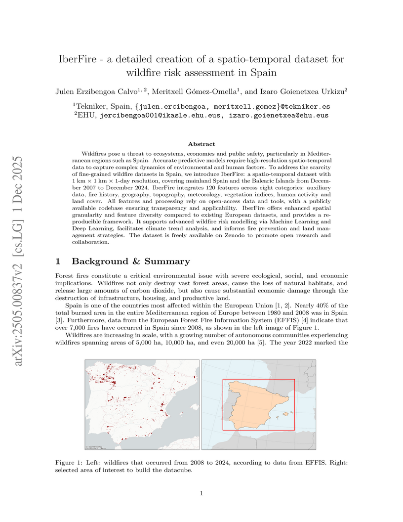
Wildfires pose a threat to ecosystems, economies and public safety, particularly in Mediterranean regions such as Spain. Accurate predictive models require high-resolution spatio-temporal data to capture complex dynamics of environmental and human factors. To address the scarcity of fine-grained wildfire datasets in Spain, we introduce IberFire: a spatio-temporal dataset with 1 km x 1 km x 1-day resolution, covering mainland Spain and the Balearic Islands from December 2007 to December 2024. IberFire integrates 120 features across eight categories: auxiliary data, fire history, geography, topography, meteorology, vegetation indices, human activity and land cover. All features and processing rely on open-access data and tools, with a publicly available codebase ensuring transparency and applicability. IberFire offers enhanced spatial granularity and feature diversity compared to existing European datasets, and provides a reproducible framework. It supports advanced wildfire risk modelling via Machine Learning and Deep Learning, facilitates climate trend analysis, and informs fire prevention and land management strategies. The dataset is freely available on Zenodo to promote open research and collaboration.
There are no more papers matching your filters at the moment.
