11 Nov 2024
Satellite clock bias prediction plays a crucial role in enhancing the accuracy of satellite navigation systems. In this paper, we propose an approach utilizing Long Short-Term Memory (LSTM) networks to predict satellite clock bias. We gather data from the PRN 8 satellite of the Galileo and preprocess it to obtain a single difference sequence, crucial for normalizing the data. Normalization allows resampling of the data, ensuring that the predictions are equidistant and complete. Our methodology involves training the LSTM model on varying lengths of datasets, ranging from 7 days to 31 days. We employ a training set consisting of two days' worth of data in each case. Our LSTM model exhibits exceptional accuracy, with a Root Mean Square Error (RMSE) of 2.11 10. Notably, our approach outperforms traditional methods used for similar time-series forecasting projects, being 170 times more accurate than RNN, 2.3 10 times more accurate than MLP, and 1.9 10 times more accurate than ARIMA. This study holds significant potential in enhancing the accuracy and efficiency of low-power receivers used in various devices, particularly those requiring power conservation. By providing more accurate predictions of satellite clock bias, the findings of this research can be integrated into the algorithms of such devices, enabling them to function with heightened precision while conserving power. Improved accuracy in clock bias predictions ensures that low-power receivers can maintain optimal performance levels, thereby enhancing the overall reliability and effectiveness of satellite navigation systems. Consequently, this advancement holds promise for a wide range of applications, including remote areas, IoT devices, wearable technology, and other devices where power efficiency and navigation accuracy are paramount.
12 Mar 2024
Aditya-L1 is the first Indian space mission to explore the Sun and solar
atmosphere with seven multi-wavelength payloads, with Visible Emission Line
Coronagraph (VELC) being the prime payload. It is an internally occulted
coronagraph with four channels to image the Sun at 5000 \AA~ in the field of
view 1.05 - 3 \rsun, and to pursue spectroscopy at 5303 \AA, 7892 \AA~ and
10747 \AA~ channels in the FOV (1.05 - 1.5 \rsun). In addition,
spectropolarimetry is planned at 10747 \AA~ channel. Therefore, VELC has three
sCMOS detectors and one InGaAs detector. In this article, we aim to describe
the technical details and specifications of the detectors achieved by way of
thermo-vacuum calibration at the CREST campus of the Indian Institute of
Astrophysics, Bangalore, India. Furthermore, we report the estimated conversion
gain, full-well capacity, and readout noise at different temperatures. Based on
the numbers, it is thus concluded that it is essential to operate the sCMOS
detectors and InGaAs detectors at and C,
respectively, at the spacecraft level.
21 Mar 2024
Jets and outflows are the early signposts of stellar birth. Using the UKIRT
Wide Field Infrared Survey for H2 (UWISH2) at 2.12 micron, 127 outflows are
identified in molecular cloud complexes Vulpecula OB1 and IRDC G53.2 covering
12 square degrees of the Galactic plane. Using multi-wavelength datasets, from
1.2 to 70 micron, 79 young stellar objects (YSOs) are proposed as potential
driving sources, where, 79% are likely Class 0/I protostars, 17% are
Class II YSOs and the remaining 4% are Class III YSOs. The outflows are
characterized in terms of their length, flux, luminosity and knot-spacing. The
identified outflows have a median lobe length of 0.22 pc and 0.17 pc for
outflows in Vulpecula OB1 and IRDC G53.2, respectively. Our analysis, from the
knot spacing, reveals a typical ejection frequency of 1.2 kyr suggesting
an intermediate type between the FU-Ori and EX-Ori type of eruptions in both
cloud complexes. Furthermore, the physical parameters of the driving sources
are obtained by performing radiative transfer modelling to the observed
spectral energy distributions (SEDs), which suggest that the outflows are
driven by intermediate mass stars. Various observed trends between the outflow
properties and the corresponding driving sources, and various interesting
outflows and star forming sites, including sites of triggered star formation
and protocluster forming clump with clusters of jets, are discussed. The
obtained results and the identified jet-bearing protostellar sample will pave
the way to understand many aspects of outflows with future high-resolution
observations.
30 Oct 2024
In ocean colour remote sensing, radiance at the sensor level can be modeled
using molecular scattering and particle scattering based on existing
mathematical models and gaseous absorption in the atmosphere. The modulation of
light field by optical constituents within the seawater waters results in the
spectral variation of water leaving radiances that can be related to
phytoplankton pigment concentration, total suspended matter, vertical diffuse
attenuation coefficients etc. Atmospheric correction works very well over open
ocean using NIR channels of ocean colour sensors to retrieve geophysical
products with reasonable accuracy while it fails over sediment laden and/or
optically complex waters. To resolve this issue, a combination of SWIR channels
or NIR-SWIR channels are configured in some ocean colour sensors such as
Sentinel- OLCI, EOS- 06 OCM etc. Ocean Colour Monitor (OCM)-3 on board EOS -06
was launched on Nov 26, 2022. It has 13 bands in VNIR (400-1010 nm range) with
~1500 km swath for ocean colour monitoring. Arabian Sea near Gujarat coast is
chosen as our study site to showcase the geophysical products derived using
OCM-3 onboard EOS-06.
24 Jun 2021
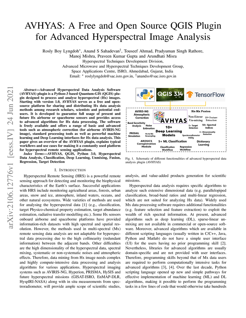
Advanced Hyperspectral Data Analysis Software (AVHYAS) plugin is a python3
based quantum GIS (QGIS) plugin designed to process and analyse hyperspectral
(Hx) images. It is developed to guarantee full usage of present and future Hx
airborne or spaceborne sensors and provides access to advanced algorithms for
Hx data processing. The software is freely available and offers a range of
basic and advanced tools such as atmospheric correction (for airborne AVIRISNG
image), standard processing tools as well as powerful machine learning and Deep
Learning interfaces for Hx data analysis.
07 Nov 2024
Most of the research work in the solar potential analysis is performed
utilizing aerial imagery, LiDAR data, and satellite imagery. However, in the
existing studies using satellite data, parameters such as trees/ vegetation
shadow, adjacent higher architectural structures, and eccentric roof structures
in urban areas were not considered, and relatively coarser-resolution datasets
were used for analysis. In this work, we have implemented a novel approach to
estimate rooftop solar potential using inputs of high-resolution satellite
imagery (0.5 cm), a digital elevation model (1m), along with ground station
radiation data. Solar radiation analysis is performed using the diffusion
proportion and transmissivity ratio derived from the ground station data hosted
by IMD. It was observed that due to seasonal variations, environmental effects
and technical reasons such as solar panel structure etc., there can be a
significant loss of electricity generation up to 50%. Based on the results, it
is also understood that using 1m DEM and 50cm satellite imagery, more authentic
results are produced over the urban areas.
07 Nov 2024
With the launch of Carto2S series of satellites, high resolution images (0.6-1.0 meters) are acquired and available for use. High resolution Digital Elevation Model (DEM) with better accuracies can be generated using C2S multi-view and multi date datasets. DEMs are further used as an input to derive Digital terrain models (DTMs) and to extract accurate heights of the objects (building and tree) over the surface of the Earth. Extracted building heights are validated with ground control points and can be used for generation of city modelling and resource estimation like population estimation, health planning, water and transport resource estimations. In this study, an attempt is made to assess the population of a township using high-resolution Indian remote sensing satellite datasets. We used Carto 2S multi-view data and generated a precise DEM and DTM over a city area. Using DEM and DTM datasets, accurate heights of the buildings are extracted which are further validated with ground data. Accurate building heights and high resolution imagery are used for generating accurate virtual 3D city model and assessing the number of floor and carpet area of the houses/ flats/ apartments. Population estimation of the area is made using derived information of no of houses/ flats/ apartments from the satellite datasets. Further, information about number of hospital and schools around the residential area is extracted from open street maps (OSM). Population estimation using satellite data and derived information from OSM datasets can prove to be very good tool for local administrator and decision makers.
11 Nov 2024
Accurate classification of buildings into residential and non-residential categories is crucial for urban planning, infrastructure development, population estimation and resource allocation. It is a complex job to carry out automatic classification of residential and nonresidential buildings manually using satellite data. In this paper, we are proposing a novel deep learning approach that combines high-resolution satellite data (50 cm resolution Image + 1m grid interval DEM) and vector data to achieve high-performance building classification. Our architecture leverages LeakyReLU and ReLU activations to capture nonlinearities in the data and employs feature-engineering techniques to eliminate highly correlated features, resulting in improved computational efficiency. Experimental results on a large-scale dataset demonstrate the effectiveness of our model, achieving an impressive overall F1 -score of 0.9936. The proposed approach offers a scalable and accurate solution for building classification, enabling informed decision-making in urban planning and resource allocation. This research contributes to the field of urban analysis by providing a valuable tool for understanding the built environment and optimizing resource utilization.

04 Nov 2024
In this study, 0.5m high resolution satellite datasets over Indian urban region was used to demonstrate the applicability of deep learning models over Ahmedabad, India. Here, YOLOv7 instance segmentation model was trained on well curated trees canopy dataset (6500 images) in order to carry out the change detection. During training, evaluation metrics such as bounding box regression and mask regression loss, mean average precision (mAP) and stochastic gradient descent algorithm were used for evaluating and optimizing the performance of model. After the 500 epochs, the mAP of 0.715 and 0.699 for individual tree detection and tree canopy mask segmentation were obtained. However, by further tuning hyper parameters of the model, maximum accuracy of 80 % of trees detection with false segmentation rate of 2% on data was obtained.
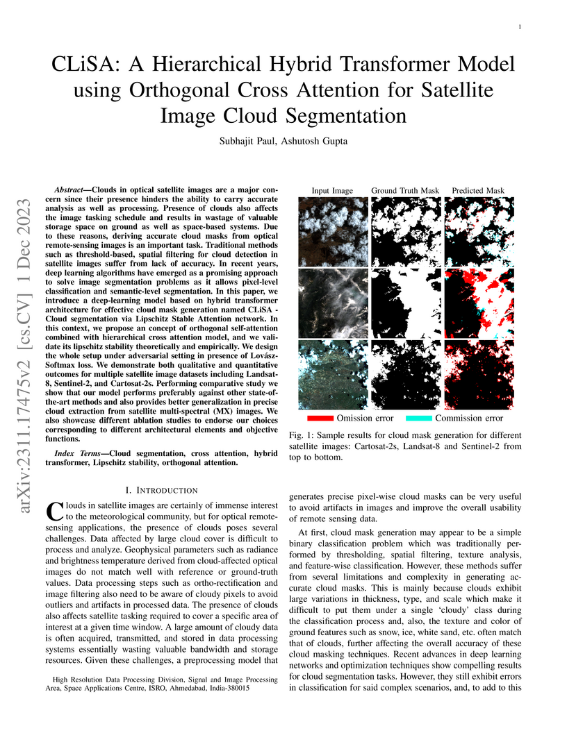
01 Dec 2023
Clouds in optical satellite images are a major concern since their presence
hinders the ability to carry accurate analysis as well as processing. Presence
of clouds also affects the image tasking schedule and results in wastage of
valuable storage space on ground as well as space-based systems. Due to these
reasons, deriving accurate cloud masks from optical remote-sensing images is an
important task. Traditional methods such as threshold-based, spatial filtering
for cloud detection in satellite images suffer from lack of accuracy. In recent
years, deep learning algorithms have emerged as a promising approach to solve
image segmentation problems as it allows pixel-level classification and
semantic-level segmentation. In this paper, we introduce a deep-learning model
based on hybrid transformer architecture for effective cloud mask generation
named CLiSA - Cloud segmentation via Lipschitz Stable Attention network. In
this context, we propose an concept of orthogonal self-attention combined with
hierarchical cross attention model, and we validate its Lipschitz stability
theoretically and empirically. We design the whole setup under adversarial
setting in presence of Lov\'asz-Softmax loss. We demonstrate both qualitative
and quantitative outcomes for multiple satellite image datasets including
Landsat-8, Sentinel-2, and Cartosat-2s. Performing comparative study we show
that our model performs preferably against other state-of-the-art methods and
also provides better generalization in precise cloud extraction from satellite
multi-spectral (MX) images. We also showcase different ablation studies to
endorse our choices corresponding to different architectural elements and
objective functions.
There are no more papers matching your filters at the moment.
