25 Apr 2025
Climate change significantly impacts public health, driving the emergence and
spread of epidemics. Climate health models are essential for assessing and
predicting disease outbreaks influenced by climatic variables like temperature
and precipitation. For instance, dengue and malaria correlate with temperature
changes, while cholera is linked to precipitation anomalies. Advances in
AI-enabled weather prediction (AI-NWP) have improved forecasting, but
integrating climate models with health systems is hindered by the lack of
comprehensive, granular health datasets. This study introduces EpiClim: India's
Epidemic-Climate Dataset, the first weekly district-wise dataset for major
epidemics in India from 2009 to the present, sourced from the Integrated
Disease Surveillance Programme (IDSP). The dataset, covering diseases like
dengue, malaria, and acute-diarrheal disease, bridges the gap between climate
and health data, enabling the integration of climate forecasts with epidemic
prediction models. This work lays the foundation for coupling predictive
climate health models with weather and climate models, advancing efforts to
mitigate climate-induced public health crises.
08 May 2024
The knowledge of type of precipitating cloud is crucial for radar based
quantitative estimates of precipitation. We propose a novel model called
CloudSense which uses machine learning to accurately identify the type of
precipitating clouds over the complex terrain locations in the Western Ghats
(WGs) of India. CloudSense uses vertical reflectivity profiles collected during
July-August 2018 from an X-band radar to classify clouds into four categories
namely stratiform,mixed stratiform-convective,convective and shallow clouds.
The machine learning(ML) model used in CloudSense was trained using a dataset
balanced by Synthetic Minority Oversampling Technique (SMOTE), with features
selected based on physical characteristics relevant to different cloud types.
Among various ML models evaluated Light Gradient Boosting Machine (LightGBM)
demonstrate superior performance in classifying cloud types with a BAC of 0.8
and F1-Score of 0.82. CloudSense generated results are also compared against
conventional radar algorithms and we find that CloudSense performs better than
radar algorithms. For 200 samples tested, the radar algorithm achieved a BAC of
0.69 and F1-Score of 0.68, whereas CloudSense achieved a BAC and F1-Score of
0.77. Our results show that ML based approach can provide more accurate cloud
detection and classification which would be useful to improve precipitation
estimates over the complex terrain of the WG.
17 May 2023
Lightning strikes are a well-known danger, and are a leading cause of accidental fatality worldwide. Unfortunately, lightning hazards seldom make headlines in international media coverage because of their infrequency and the low number of casualties each incidence. According to readings from the TRMM LIS lightning sensor, thunderstorms are more common in the tropics while being extremely rare in the polar regions. To improve the precision of lightning forecasts, we develop a technique similar to LightNet's, with one key modification. We didn't just base our model off the results of preliminary numerical simulations; we also factored in the observed fields' time-dependent development. The effectiveness of the lightning forecast rose dramatically once this adjustment was made. The model was tested in a case study during a thunderstorm. Using lightning parameterization in the WRF model simulation, we compared the simulated fields. As the first of its type, this research has the potential to set the bar for how regional lightning predictions are conducted in the future because of its data-driven approach. In addition, we have built a cloud-based lightning forecast system based on Google Earth Engine. With this setup, lightning forecasts over West India may be made in real time, giving critically important information for the area.
10 Dec 2021
Climate change has become one of the biggest global problems increasingly
compromising the Earth's habitability. Recent developments such as the
extraordinary heat waves in California & Canada, and the devastating floods in
Germany point to the role of climate change in the ever-increasing frequency of
extreme weather. Numerical modelling of the weather and climate have seen
tremendous improvements in the last five decades, yet stringent limitations
remain to be overcome. Spatially and temporally localized forecasting is the
need of the hour for effective adaptation measures towards minimizing the loss
of life and property. Artificial Intelligence-based methods are demonstrating
promising results in improving predictions, but are still limited by the
availability of requisite hardware and software required to process the vast
deluge of data at a scale of the planet Earth. Quantum computing is an emerging
paradigm that has found potential applicability in several fields. In this
opinion piece, we argue that new developments in Artificial Intelligence
algorithms designed for quantum computers - also known as Quantum Artificial
Intelligence (QAI) - may provide the key breakthroughs necessary to furthering
the science of climate change. The resultant improvements in weather and
climate forecasts are expected to cascade to numerous societal benefits.
23 May 2022
Soil moisture (SM) is referred to as a finite amount of water molecules within the pore spaces and it is a crucial parameter of Hydro-Meteorological processes. The behaviour of soil moisture water changes spatially and temporally in response to topography, soil characteristics, and climate[1]. Soil moisture is overseen by various hydro-meteorological factors that vary vertically with depth, laterally across terrestrial shapes, and temporarily in feedback to the climate. The precise monitoring and quantification of high-resolution surface and subsurface soil moisture observations are very important [13]. This paper highlights the outcomes of the fieldwork carried out at IITM, Pune, wherein we have developed a soil moisture and temperature measurement system using Raspberry Pi and the Internet of things (IoT). The development is classified into three stages, the first stage includes the assembly of the sensor with the microprocessor. The deployment of the low-cost system, data generation, and communication through a wireless sensor network is part of the second stage. Finally, the third stage includes real-time data visualization using a mobile application and data server for analysing soil moisture and temperature. The soil moisture profile obtained through the sensor deployed is highly correlated (r=.9) with in-situ gravimetric observations, having a root mean square error (RMSE) of about 3.1%. Similarly, the temperature observations are well-matched with the in-situ standard temperature observation. Here we present the preliminary results and compare the accuracy with the state-of-the-art sensors.
11 Nov 2022
 The University of Texas at AustinIndian Institute of Technology, BombayUniversity of Colorado BoulderOden Institute for Computational Engineering and SciencesDefence Institute of Advanced TechnologyIndian Institute of Tropical MeteorologyMinistry of Earth SciencesNOAA/Physical Sciences LaboratoryCIRESJackson School of Geosciences
Precipitation governs Earth's hydroclimate, and its daily spatiotemporal fluctuations have major socioeconomic effects. Advances in Numerical weather prediction (NWP) have been measured by the improvement of forecasts for various physical fields such as temperature and pressure; however, large biases exist in precipitation prediction. We augment the output of the well-known NWP model CFSv2 with deep learning to create a hybrid model that improves short-range global precipitation at 1-, 2-, and 3-day lead times. To hybridise, we address the sphericity of the global data by using modified DLWP-CS architecture which transforms all the fields to cubed-sphere projection. Dynamical model precipitation and surface temperature outputs are fed into a modified DLWP-CS (UNET) to forecast ground truth precipitation. While CFSv2's average bias is +5 to +7 mm/day over land, the multivariate deep learning model decreases it to within -1 to +1 mm/day. Hurricane Katrina in 2005, Hurricane Ivan in 2004, China floods in 2010, India floods in 2005, and Myanmar storm Nargis in 2008 are used to confirm the substantial enhancement in the skill for the hybrid dynamical-deep learning model. CFSv2 typically shows a moderate to large bias in the spatial pattern and overestimates the precipitation at short-range time scales. The proposed deep learning augmented NWP model can address these biases and vastly improve the spatial pattern and magnitude of predicted precipitation. Deep learning enhanced CFSv2 reduces mean bias by 8x over important land regions for 1 day lead compared to CFSv2. The spatio-temporal deep learning system opens pathways to further the precision and accuracy in global short-range precipitation forecasts.
24 Aug 2021
The formation of precipitation in state-of-the-art weather and climate models
is an important process. The understanding of its relationship with other
variables can lead to endless benefits, particularly for the world's monsoon
regions dependent on rainfall as a support for livelihood. Various factors play
a crucial role in the formation of rainfall, and those physical processes are
leading to significant biases in the operational weather forecasts. We use the
UNET architecture of a deep convolutional neural network with residual learning
as a proof of concept to learn global data-driven models of precipitation. The
models are trained on reanalysis datasets projected on the cubed-sphere
projection to minimize errors due to spherical distortion. The results are
compared with the operational dynamical model used by the India Meteorological
Department. The theoretical deep learning-based model shows doubling of the
grid point, as well as area averaged skill measured in Pearson correlation
coefficients relative to operational system. This study is a proof-of-concept
showing that residual learning-based UNET can unravel physical relationships to
target precipitation, and those physical constraints can be used in the
dynamical operational models towards improved precipitation forecasts. Our
results pave the way for the development of online, hybrid models in the
future.
18 Aug 2022
Simulation of turbulent flows, especially at the edges of clouds in the atmosphere, is an inherently challenging task. Hitherto, the best possible computational method to perform such experiments is the Direct Numerical Simulation (DNS). DNS involves solving non-linear partial differential equations for fluid flows, also known as Navier-Stokes equations, on discretized grid boxes in a three-dimensional space. It is a valuable paradigm that has guided the numerical weather prediction models to compute rainfall formation. However, DNS cannot be performed for large domains of practical utility to the weather forecast community. Here, we introduce this http URL, a 3D-UNET that simulates the outputs of a rising cloud DNS experiment. The problem of increasing the domain size in DNS is addressed by mapping an inner 3D cube to the complete 3D cube from the output of the DNS discretized grid simulation. Our approach effectively captures turbulent flow dynamics without having to solve the complex dynamical core. The baseline shows that the deep learning-based simulation is comparable to the partial-differential equation-based model as measured by various score metrics. This framework can be used to further the science of turbulence and cloud flows by enabling simulations over large physical domains in the atmosphere. It would lead to cascading societal benefits by improved weather predictions via advanced parameterization schemes.
20 Oct 2022
Massive river interlinking projects are proposed to offset observed increasing trends of extremes, such as droughts and floods in India, the second highest populated this http URL river interlinking projects involve water transfer from surplus to deficit river basins through reservoirs and canals, but without an in-depth understanding of the hydro-meteorological consequences. Using information theory-based causal delineation techniques, a coupled regional climate model, and multiple reanalysis datasets, we show that causal pathways exist across different basins in India due to strong land-atmosphere feedback, which disputes the generally practiced assumption of hydrological independence between river basins. The causal information from one basin's land crosses the basin boundary through the atmosphere. We further find that increased irrigation from the transferred water reduces mean rainfall in September by up to 12% in many parts of India most of which are already water this http URL observe more drying in La Nina years as compared to El Nino years. Reduced September precipitation can lead to drying of rivers post monsoon augmenting the water stress across country rendering interlinking dysfunctional. These findings demand model-guided impact assessment studies of large scale hydrological projects across the globe considering land-atmosphere interactions.
12 Apr 2023
Cognitive psychology delves on understanding perception, attention, memory,
language, problem-solving, decision-making, and reasoning. Large language
models (LLMs) are emerging as potent tools increasingly capable of performing
human-level tasks. The recent development in the form of GPT-4 and its
demonstrated success in tasks complex to humans exam and complex problems has
led to an increased confidence in the LLMs to become perfect instruments of
intelligence. Although GPT-4 report has shown performance on some cognitive
psychology tasks, a comprehensive assessment of GPT-4, via the existing
well-established datasets is required. In this study, we focus on the
evaluation of GPT-4's performance on a set of cognitive psychology datasets
such as CommonsenseQA, SuperGLUE, MATH and HANS. In doing so, we understand how
GPT-4 processes and integrates cognitive psychology with contextual
information, providing insight into the underlying cognitive processes that
enable its ability to generate the responses. We show that GPT-4 exhibits a
high level of accuracy in cognitive psychology tasks relative to the prior
state-of-the-art models. Our results strengthen the already available
assessments and confidence on GPT-4's cognitive psychology abilities. It has
significant potential to revolutionize the field of AI, by enabling machines to
bridge the gap between human and machine reasoning.
25 May 2023
Tianjin University University of Cambridge
 Chinese Academy of Sciences
 University of ManchesterUniversity of LjubljanaThe University of Melbourne
 University of Texas at Austin
 MicrosoftThe University of New South Wales (UNSW)Indian Institute of TechnologyCardiff University
 Queen Mary University of LondonUniversity of BirminghamUniversity of Western OntarioVienna University of TechnologyIndian Institute of Tropical MeteorologyRaygun Performance MonitoringKings EducationCymax Group TechnologiesMachine Intelligence Research Labs
University of CambridgeChinese Academy of SciencesUniversity of ManchesterUniversity of LjubljanaThe University of MelbourneUniversity of Texas at AustinMicrosoftThe University of New South Wales (UNSW)Indian Institute of TechnologyCardiff UniversityQueen Mary University of LondonUniversity of BirminghamUniversity of Western OntarioVienna University of TechnologyIndian Institute of Tropical MeteorologyRaygun Performance MonitoringKings EducationCymax Group TechnologiesMachine Intelligence Research LabsChatGPT, an AI-based chatbot, was released to provide coherent and useful replies based on analysis of large volumes of data. In this article, leading scientists, researchers and engineers discuss the transformative effects of ChatGPT on modern education. This research seeks to improve our knowledge of ChatGPT capabilities and its use in the education sector, identifying potential concerns and challenges. Our preliminary evaluation concludes that ChatGPT performed differently in each subject area including finance, coding and maths. While ChatGPT has the ability to help educators by creating instructional content, offering suggestions and acting as an online educator to learners by answering questions and promoting group work, there are clear drawbacks in its use, such as the possibility of producing inaccurate or false data and circumventing duplicate content (plagiarism) detectors where originality is essential. The often reported hallucinations within Generative AI in general, and also relevant for ChatGPT, can render its use of limited benefit where accuracy is essential. What ChatGPT lacks is a stochastic measure to help provide sincere and sensitive communication with its users. Academic regulations and evaluation practices used in educational institutions need to be updated, should ChatGPT be used as a tool in education. To address the transformative effects of ChatGPT on the learning environment, educating teachers and students alike about its capabilities and limitations will be crucial.
19 Nov 2024

Urbanization is advancing rapidly, covering less than 2% of Earth's surface
yet profoundly influencing global environments and experiencing
disproportionate impacts from extreme weather events. Effective urban
management and planning require high-resolution, temporally consistent datasets
that capture the complexity of urban growth and dynamics. This study presents
NDUI+, a novel global urban dataset addressing critical gaps in urban data
continuity and quality. NDUI+ integrates data from the Defense Meteorological
Satellite Program's Operational Linescan System (DMSP-OLS), VIIRS Nighttime
Light, and Landsat 7 NDVI using advanced remote sensing and deep learning
techniques. The dataset resolves sensor discontinuity challenges, offering a
seamless 30-meter spatial and annual temporal resolution time series from 1999
to the present. NDUI+ demonstrates high precision and granularity, aligning
closely with high-resolution satellite data and capturing urban dynamics
effectively. The dataset provides valuable insights for urban climate studies,
IPCC assessments, and urbanization research, complementing resources like
UT-GLOBUS for urban modeling.
12 Oct 2024
Droplet growth and size spectra play a crucial role in the microphysics of atmospheric clouds. However, it is challenging to represent droplet growth rate accurately in cloud-resolving models such as Large Eddy Simulations (LESs). The assumption of "well-mixed" condition within each grid cell, often made by traditional LES solvers, typically falls short near the edges of clouds, where sharp gradients in water vapor supersaturation occur. This under-resolution of supersaturation gradients can lead to significant errors in prediction of droplet growth rate, which in turn affects the prediction of buoyancy at cloud edges, as well as forecast of precipitation. In "superdroplet" based LES model, a Lagrangian coarse-graining approach groups multiple droplets into superdroplets, each encompassing a specific number and size of actual droplets. The superdroplets are advected by the underlying LES velocity field, and the growth rate of these superdroplets is based on the filtered supersaturation field represented by the LES. To overcome the limitations of the "well-mixed" assumption, we propose a parameterization for superdroplet growth using high-fidelity Direct Numerical Simulation (DNS) data. We introduce a novel clustering algorithm to map droplets in DNS fields to superdroplets. The effective supersaturation at each superdroplet location is computed by averaging the unfiltered supersaturation of the associated droplets, which may differ from the value of filtered supersaturation at the superdroplet location. We then develop a machine learning-based parameterization to relate the effective growth rate of superdroplets to other filtered DNS flow variables. Preliminary results show a promising value of nearly 0.9 between the predicted and true effective supersaturation values for the superdroplets, for a range of superdroplet multiplicities.
14 Oct 2024
This study presents an innovative approach to creating a dynamic, AI based emission inventory system for use with the Weather Research and Forecasting model coupled with Chemistry (WRF Chem), designed to simulate vehicular and other anthropogenic emissions at satellite detectable resolution. The methodology leverages state of the art deep learning based computer vision models, primarily employing YOLO (You Only Look Once) architectures (v8 to v10) and T Rex, for high precision object detection. Through extensive data collection, model training, and finetuning, the system achieved significant improvements in detection accuracy, with F1 scores increasing from an initial 0.15 at 0.131 confidence to 0.72 at 0.414 confidence. A custom pipeline converts model outputs into netCDF files storing latitude, longitude, and vehicular count data, enabling real time processing and visualization of emission patterns. The resulting system offers unprecedented temporal and spatial resolution in emission estimates, facilitating more accurate short term air quality forecasts and deeper insights into urban emission dynamics. This research not only enhances WRF Chem simulations but also bridges the gap between AI technologies and atmospheric science methodologies, potentially improving urban air quality management and environmental policymaking. Future work will focus on expanding the system's capabilities to non vehicular sources and further improving detection accuracy in challenging environmental conditions.
08 Apr 2025

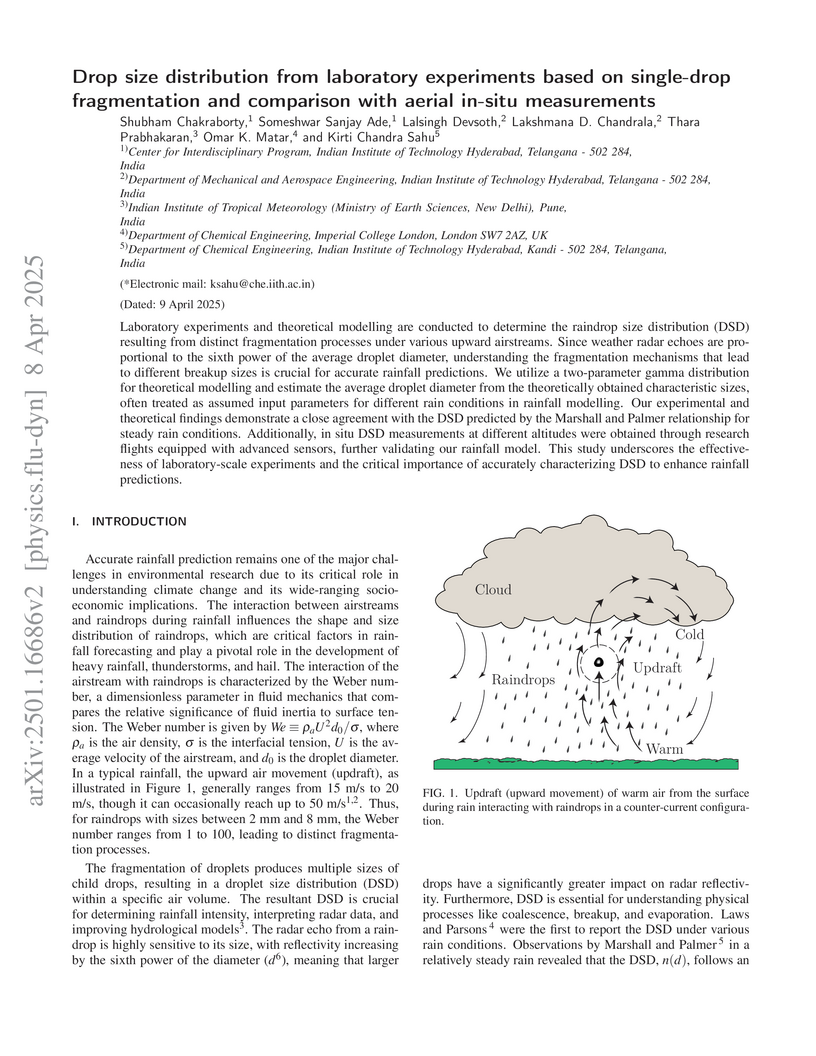
Laboratory experiments and theoretical modelling are conducted to determine the raindrop size distribution (DSD) resulting from distinct fragmentation processes under various upward airstreams. Since weather radar echoes are proportional to the sixth power of the average droplet diameter, understanding the fragmentation mechanisms that lead to different breakup sizes is crucial for accurate rainfall predictions. We utilize a two-parameter gamma distribution for theoretical modelling and estimate the average droplet diameter from the theoretically obtained characteristic sizes, often treated as assumed input parameters for different rain conditions in rainfall modelling. Our experimental and theoretical findings demonstrate a close agreement with the DSD predicted by the Marshall and Palmer relationship for steady rain conditions. Additionally, in situ DSD measurements at different altitudes were obtained through research flights equipped with advanced sensors, further validating our rainfall model. This study underscores the effectiveness of laboratory-scale experiments and the critical importance of accurately characterizing DSD to enhance rainfall predictions.
18 Mar 2025
Accurate precipitation estimates at individual locations are crucial for
weather forecasting and spatial analysis. This study presents a paradigm shift
by leveraging Deep Neural Networks (DNNs) to surpass traditional methods like
Kriging for station-specific precipitation approximation. We propose two
innovative NN architectures: one utilizing precipitation, elevation, and
location, and another incorporating additional meteorological parameters like
humidity, temperature, and wind speed. Trained on a vast dataset (1980-2019),
these models outperform Kriging across various evaluation metrics (correlation
coefficient, root mean square error, bias, and skill score) on a five-year
validation set. This compelling evidence demonstrates the transformative power
of deep learning for spatial prediction, offering a robust and precise
alternative for station-specific precipitation estimation.
30 Nov 2010
Atmospheric flows, an example of turbulent fluid flows, exhibit fractal fluctuations of all space-time scales ranging from turbulence scale of mm -sec to climate scales of thousands of kilometers - years and may be visualized as a nested continuum of weather cycles or periodicities, the smaller cycles existing as intrinsic fine structure of the larger cycles. The power spectra of fractal fluctuations exhibit inverse power law form signifying long - range correlations identified as self - organized criticality and are ubiquitous to dynamical systems in nature and is manifested as sensitive dependence on initial condition or 'deterministic chaos' in finite precision computer realizations of nonlinear mathematical models of real world dynamical systems such as atmospheric flows. Though the selfsimilar nature of atmospheric flows have been widely documented and discussed during the last three to four decades, the exact physical mechanism is not yet identified. There now exists an urgent need to develop and incorporate basic physical concepts of nonlinear dynamics and chaos into classical meteorological theory for more realistic simulation and prediction of weather and climate. A review of nonlinear dynamics and chaos in meteorology and atmospheric physics is summarized in this paper.
10 May 2022


We investigate the intermittent dynamics of momentum transport and its underlying time scales in the near-wall region of the neutrally stratified atmospheric boundary layer in the presence of a vegetation canopy. This is achieved through an empirical analysis of the persistence time scales (periods between successive zero-crossings) of momentum flux events, and their connection to the ejection-sweep cycle. Using high-frequency measurements from the GoAmazon campaign, spanning multiple heights within and above a dense canopy, the analysis suggests that when the persistence time scales () of momentum flux events from four different quadrants are separately normalized by (integral time scale of the vertical velocity), their distributions () remain height-invariant. This result points to a persistent memory imposed by canopy-induced coherent structures, and to their role as an efficient momentum transport mechanism between the canopy airspace and the region immediately above. Moreover, exhibits a power-law scaling at times t_{p}<\Gamma_{w} with an exponential tail appearing for . By separating the flux events based on , we discover that around 80\% of the momentum is transported through the long-lived events () at heights immediately above the canopy while the short-lived ones (t_{p} < \Gamma_{w}) only contribute marginally ( 20\%). To explain the role of instantaneous flux amplitudes towards momentum transport, we compare the measurements with a newly-developed surrogate data and establish that the range of time scales involved with amplitude variations in the fluxes tend to increase as one transitions from within to above the canopy.
19 Apr 2020
In the backdrop of a revolution in weather prediction by Numerical Weather Prediction (NWP) models, quantitative prediction of intensity of heavy rainfall events and associated disasters has remained a challenge. Encouraged by compelling evidence of electrical influences on cloud/rain microphysical processes, here we propose a hypothesis that modification of raindrop size distribution (RDSD) towards larger drop sizes through enhanced collision-coalescence facilitated by cloud electric fields could be one of the factors responsible for intensity errors in weather/climate models. The robustness of the hypothesis is confirmed through a series of simulations of strongly electrified (SE) rain events and weakly electrified (WE) events with a convection-permitting weather prediction model incorporating the electrically modified RDSD parameters in the model physics. Our results indicate a possible roadmap for improving hazard prediction associated with extreme rainfall events in weather prediction models and climatological dry bias of precipitation simulation in many climate models.
14 Mar 2000
Analysis of MST radar observations at Gadanki (near Tirupati, India), for a
period of 14 months from 1995 September to 1996 November, shows that "Clear air
Turbulence" is not the primary source of high MST radar reflectivity; this
conventional idea needs to be modified. An alternative hypothesis based on the
microphysics and microdynamics associated with aerosols and water substance in
the atmosphere, is presented here.
There are no more papers matching your filters at the moment.
